Western Australia
Western Australia (WA) is a state occupying the western 33 per cent of the land area of Australia, excluding external territories. It is bounded by the Indian Ocean to the north and west, the Southern Ocean to the south, the Northern Territory to the north-east, and South Australia to the south-east. Western Australia is Australia’s largest state, with a total land area of 2,527,013 square kilometres (975,685 sq mi).
Read more on Western Australia https://en.wikipedia.org/wiki/Western_Australia
Map of Western Australia
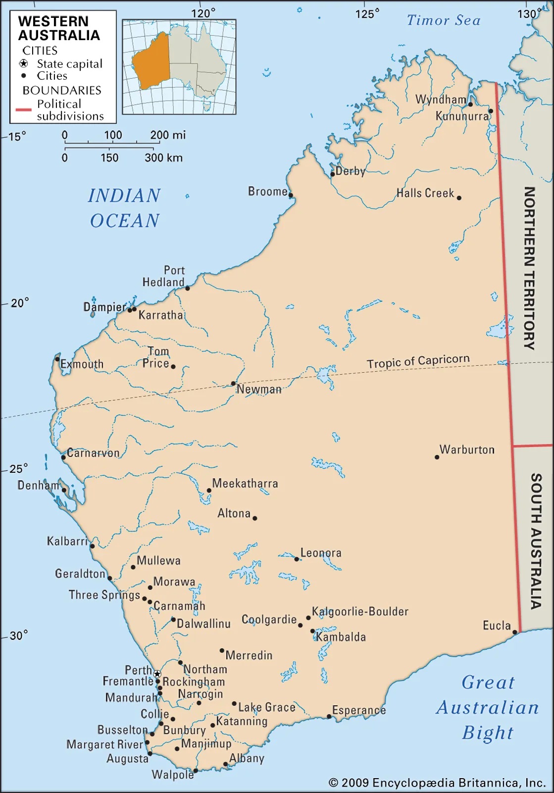
For more on Western Australia Map https://www.britannica.com/place/Western-Australia
Coat of Arms for Western Australia
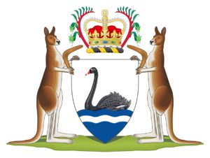 The coat of arms of Western Australia is the official coat of arms of the Australian state of Western Australia. It was granted by a royal warrant of Elizabeth II, Queen of Australia, dated 17 March 1969. The shield has a silver field, with a rippled blue and silver base. A black swan in its natural colour swims on the upper blue ripple.
The crest is the Royal Crown in its proper colours on a wreath or torse of black and gold between two kangaroo paw flowers in their natural colours of red and green.
The supporters are a red kangaroo on the dexter and sinister (the viewer’s right and left) holding up the shield. They are each depicted ‘proper’, or in natural colours. Each kangaroo holds in their forepaw a boomerang without any marks or symbols on it, and they stand upon a grassy compartment.
For more on the Western Australia Coat of Arms https://en.wikipedia.org/wiki/Coat_of_arms_of_Western_Australia
Flag for Western Australia
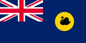 The flag of Western Australia consists of a Blue Ensign defaced with the badge of the state. Adopted in 1953 to replace a similar design used from the time when the state was still a British colony, it has been the flag of Western Australia since 3 November of that year. The design of the present flag entailed reversing the direction of the black swan so that it faced toward the hoist. Australia’s flag is similar to the flags of the other five Australian states, which are also Blue Ensigns with their respective state badges. When flown with those state flags and the national flag, it is sixth in the order of precedence. This is indicative of its position on the Commonwealth Coat of Arms.
For more on the Western Australia Flag https://en.wikipedia.org/wiki/Flag_of_Western_Australia
Emblems of Western Australia
Animal Emblem
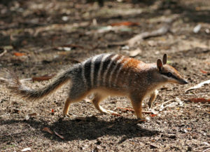 The numbat, also known as the noombat or walpurti, is an insectivorous marsupial. It is diurnal and its diet consists almost exclusively of termites.
The species was once widespread across southern Australia but is now restricted to several small colonies in Western Australia. It is therefore considered an endangered species and protected by conservation programs. Numbats were recently reintroduced to fenced reserves in South Australia and New South Wales. The numbat is the faunal emblem of Western Australia.
Bird Emblem
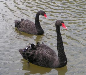 The black swan is a large waterbird, a species of swan that breeds mainly in the southeast and southwest regions of Australia. Within Australia, the black swan is nomadic, with erratic migration patterns dependent upon climatic conditions. It is a large bird with mostly black plumage and a red bill. It is a monogamous breeder, with both partners sharing incubation and cygnet-rearing duties.
Floral Emblem
 The red-and-green kangaroo paw, Mangle’s kangaroo paw, Kurulbrang, is a plant species endemic to Western Australia, and the floral emblem of that state.
The flower has become symbolic of the region. The display between August and November is remarkable for the high-standing flowers occurring in urban and coastal regions. The species is not threatened but is protected under state legislation. A license is required for collection from the wild. It is desirable as a cut flower, possessing an unusual form and striking colours that last well.
Marine Emblem
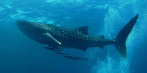 The whale shark is a slow-moving, filter-feeding carpet shark and the largest known extant fish species. The largest confirmed individual had a length of 18.8 m (61.7 ft). The whale shark holds many records for size in the animal kingdom, most notably being by far the largest living nonmammalian vertebrate.
The whale shark is found in the open waters of the tropical oceans and is rarely found in water below 21 °C (70 °F). Studies looking at vertebral growth bands and the growth rates of free-swimming sharks have estimated whale shark lifespans at 80–130 years. Whale sharks have very large mouths and are filter feeders, which is a feeding mode that occurs in only two other sharks, the megamouth shark and the basking shark. They feed almost exclusively on plankton and small fish and pose no threat to humans.
Fossil Emblem
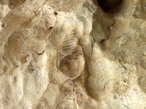 The Gogo fish is the fossil emblem for Western Australia. Gogonasus (meaning “snout from Gogo”) was a lobe-finned fish known from three-dimensionally preserved 380-million-year-old fossils found in the Gogo Formation in Western Australia. It lived in the Late Devonian period, on what was once a 1,400-kilometre coral reef off the Kimberley coast surrounding northwest Australia. Gogonasus was a small fish reaching 30–40 cm (1 ft) in length.
For more on Western Australia’s Emblems https://en.wikipedia.org/wiki/Symbols_of_Western_Australia
Colour Emblem
Gold, White and Black
For more on the Colour Emblems https://en.wikipedia.org/wiki/Australian_state_and_territory_colours
Island Governed by Western Australia
Dirk Hartog Island
-
- Location: Shark Bay, off the coast of Western Australia
- Population: Uninhabited (except for seasonal tourism and conservation staff)
- Governed by: Western Australia (within Shark Bay World Heritage Area)
Dirk Hartog Island is the largest island in Western Australia, stretching 80 km in length and forming part of the Shark Bay World Heritage Area, a UNESCO-listed site renowned for its ecological significance. The island is best known as the site of the first recorded European landing on Australian soil, by Dutch explorer Dirk Hartog in 1616.
This rugged, windswept island offers a blend of coastal adventure, pristine wilderness, and historical intrigue. It’s also the centre of one of Australia’s most ambitious ecological restoration projects.
Historical Significance
-
-
- In 1616, Dirk Hartog landed on the island aboard the Eendracht and left behind a pewter plate inscribed with details of his voyage, the earliest known European artefact linked to Australia.
- The site, now called Cape Inscription, is one of the most important places in Australia’s maritime history.
-
Ecological Importance
Dirk Hartog Island is the focus of Return to 1616, a major biodiversity restoration project led by the Western Australian government. The aim is to restore the island’s ecosystem to its pre-European state by eradicating introduced pests and reintroducing at least 13 native species, including:
-
-
- Banded hare-wallabies
- Rufous hare-wallabies
- Shark Bay mice
- Western thick-billed grass wrens
-
This project makes Dirk Hartog one of the most important conservation zones in Australia.
Natural Attractions & Activities
-
-
- Cape Inscription:
Visit the historic landing site of Dirk Hartog and see the replica pewter plate marking the first European presence in Australia. - 4WD Adventures:
The island is accessible by high clearance 4WD only, and you can explore remote beaches, dunes, and rugged cliffs. - Snorkelling & Diving:
Surrounding waters offer excellent snorkelling, particularly in the clear lagoons and coral reefs near Surf Point and Withnell Point. - Fishing:
The island is renowned for land-based game fishing, with opportunities to catch tailor, pink snapper, and Spanish mackerel. - Whale Watching & Wildlife:
From June to October, you can spot humpback whales migrating past the island. Dolphins, dugongs, turtles, and seabirds are also abundant.
- Cape Inscription:
-
Accommodation & Access
-
-
- Dirk Hartog Island Eco Lodge:
A luxury wilderness lodge offering beachfront accommodation, fishing tours, and eco-tourism experiences. - Camping:
Available at designated sites with bookings through WA Parks and Wildlife. You must be self-sufficient.
- Dirk Hartog Island Eco Lodge:
-
Getting there:
-
-
-
- 4WD access via barge from Steep Point (the westernmost tip of the Australian mainland)
- Charter flights or boat transfers are available from Denham or Monkey Mia
-
-
Why Visit Dirk Hartog Island?
Dirk Hartog Island offers the ultimate off-the-grid wilderness experience. It’s perfect for history buffs, serious adventurers, eco-tourists, and those looking to disconnect from modern life and connect with untamed nature and Australian heritage. With its rare wildlife, windswept shores, and remote charm, the island is a living time capsule, slowly returning to the way it was when first seen by European eyes over 400 years ago.
Barrow Island
-
-
- Location: Indian Ocean, 50 km off the Pilbara coast of Western Australia
- Population: No permanent residents (rotating workforce only)
- Governed by: Western Australia
- Access: Strictly controlled; not open to the public
-
Barrow Island is a striking paradox—a Class A Nature Reserve that’s also home to one of the world’s largest onshore oilfields. Located off the Pilbara coast in the resource-rich north-west of Western Australia, Barrow Island is an ecological sanctuary renowned for its pristine biodiversity and biosecurity protocols, while also playing a key role in the state’s energy production.
Environmental Significance
Barrow Island is often called “Australia’s Ark” due to its status as one of the last refuges for several endangered and vulnerable species that have disappeared from the mainland, including:
- Bettongs
- Golden bandicoots
- Barrow Island euro (a unique wallaroo subspecies)
- Boodies (burrowing bettongs)
- Reptiles and small marsupials are found nowhere else on Earth
With no cats or foxes ever introduced, the island’s native species have been able to survive without the pressures that decimated populations on the mainland.
Strict Biosecurity
Barrow Island has one of the strictest quarantine systems in the world. Every person, tool, and shipment is thoroughly inspected to ensure no pests or diseases enter the island. This biosecurity regime has been credited with keeping the island’s ecosystem intact despite industrial development.
Energy & Industry
-
-
- Oil Production:
Discovered in 1964, Barrow Island is the site of Australia’s largest and oldest onshore oilfield, operated by Chevron Australia. Production continues today with minimal surface disruption. - Gorgon LNG Project:
One of the world’s largest natural gas projects, the Gorgon Project, is located partly on Barrow Island. It includes a liquefied natural gas plant and a major carbon capture and storage (CCS) facility aimed at reducing emissions.
- Oil Production:
-
This project sparked global attention due to its scale and the unprecedented environmental safeguards put in place to allow it to operate on a Class A Nature Reserve.
Tourism & Access
Barrow Island is not open to the public. Access is restricted to authorised personnel working with Chevron or its contractors. All entries are subject to rigorous environmental training and quarantine procedures.
Why It Matters
Barrow Island is a rare example of industrial activity coexisting with high-level environmental protection. It serves as a case study in balancing resource extraction with conservation and is closely watched by scientists, governments, and environmentalists around the world.
It’s not a holiday destination, but it is one of Australia’s most important environmental success stories, and a vital component of the country’s energy strategy.
Augustus Island
-
-
- Location: Kimberley region, northwestern Western Australia
- Size: ~190 km² (one of the largest islands in the Kimberley)
- Population: Uninhabited
- Governed by: Western Australia
- Access: By private boat or Kimberley cruise (remote and undeveloped)
-
Augustus Island is a rugged, remote, and ecologically rich island located in the Bonaparte Archipelago, off the Kimberley coast of Western Australia. With its towering cliffs, secluded bays, and unique flora and fauna, Augustus is considered one of the most significant islands in the Kimberley, both geologically and ecologically.
Ecological Importance
Augustus Island is a biodiversity hotspot, particularly for endemic plants, reptiles, and small mammals. Because it has been free of invasive predators such as foxes and cats, it serves as a natural refuge for species that are declining or extinct on the mainland.
Notable fauna includes:
-
-
- Northern quolls
- Monjons (a small rock wallaby)
- Rare geckos and skinks
- A variety of seabirds and shorebirds
- Marine life in surrounding waters: dugongs, sea turtles, and dolphins
-
The island’s rugged sandstone landscape and isolation have helped it retain much of its natural character.
Landscape & Geology
-
-
- Composed primarily of ancient sandstone escarpments, Augustus Island features steep cliffs, dry gorges, and rocky outcrops typical of the Kimberley region.
- It also has mangrove-lined bays, tidal creeks, and sandy beaches, making it a visually striking destination from both land and sea.
-
Access & Tourism
Augustus Island is not serviced by regular transport, and there are no settlements or facilities on the island. However, it can be accessed via:
-
-
- Kimberley expedition cruises (from Broome or Darwin)
- Private yachts or boats exploring the Bonaparte Archipelago
-
Visitors to the area often stop for birdwatching, wildlife photography, or fishing, though access to the island itself may be limited due to tides and its undeveloped nature.
Conservation & Research
While there are no current permanent research stations on Augustus Island, it has been the subject of biological surveys by the WA Department of Biodiversity, Conservation and Attractions. These surveys highlight the island’s value in protecting Kimberley-native species and understanding pre-European ecosystems.
Due to its isolation and ecological integrity, Augustus Island is considered a valuable natural sanctuary and is occasionally included in long-term regional conservation planning.
Why Visit (or Know About) Augustus Island?
Though not a conventional tourist destination, Augustus Island represents the untouched wilderness that makes the Kimberley region so special. It is part of a greater network of islands that preserve rare species, unique ecosystems, and ancient landscapes found nowhere else on Earth.
For nature lovers, researchers, and adventurers, Augustus Island is a symbol of the raw and remote beauty of northwestern Australia.
Bigge Island
-
-
- Location: Off the Kimberley coast, Western Australia (north of Prince Regent River)
- Size: Approx. 178 km²
- Population: Uninhabited
- Governed by: Western Australia
- Traditional Owners: Wunambal Gaambera people
- Access: By boat or Kimberley expedition cruise
-
Bigge Island is one of the most scenically stunning and culturally significant islands along the remote Kimberley coast. Renowned for its striking sandstone cliffs, hidden caves, abundant wildlife, and ancient Indigenous rock art, Bigge Island is a key stop on many Kimberley coastal cruises and holds deep spiritual importance for its Traditional Owners, the Wunambal Gaambera people.
Cultural & Spiritual Significance
Bigge Island is home to numerous Aboriginal rock art sites, including iconic Wandjina and Gwion Gwion (Bradshaw) figures painted in ochre on the island’s sandstone surfaces and in rock shelters.
-
-
- The Wandjina are cloud and rain spirits central to the Wunambal Gaambera cosmology.
- The Gwion Gwion are finely detailed figures believed to be thousands of years old, depicting ancient ceremonial scenes.
-
These artworks reflect the deep and continuous cultural connection of the Traditional Owners to the island, and visitors are asked to treat the sites with respect and care.
Natural Environment & Wildlife
Bigge Island has never been impacted by feral predators like cats or foxes, making it a sanctuary for native species, including:
-
-
- Monjons (a small rock wallaby found only in the Kimberley islands)
- Northern quolls
- Crested terns and seabird colonies
- Turtles, dugongs, and dolphins in the surrounding waters
-
The island’s vegetation includes spinifex grasslands, mangroves, and coastal shrublands, supporting a diversity of insects, reptiles, and birdlife.
Landscape & Geology
Bigge Island features dramatic sandstone cliffs, wave-sculpted caves, and a rugged, ancient terrain. Its coastline is dotted with sheltered bays, tidal creeks, and beach landings, making it ideal for small-ship cruise landings and guided walks.
Access & Activities
Access is limited to expedition cruises, such as those departing from Broome or Darwin, and occasional private boats.
Popular activities include:
-
-
- Guided tours of rock art galleries
- Wildlife spotting and birdwatching
- Photography of the island’s unique landforms
- Cultural interpretation from Indigenous rangers and guides (where available)
-
There are no facilities or infrastructure on the island, and all visits are conducted in line with conservation and cultural protection principles.
Conservation Status
Bigge Island is part of the North Kimberley Marine Park and falls under joint management between the Western Australian government and the Wunambal Gaambera Aboriginal Corporation. This co-management approach helps preserve the natural and cultural heritage of the area.
Why Visit Bigge Island?
Bigge Island is not just a destination—it’s a cultural and environmental treasure. With its untouched wilderness, ancient Aboriginal heritage, and abundant wildlife, it offers a rare chance to experience one of the most authentic and spiritually powerful places in Australia.
Ideal for those seeking an immersive nature and culture journey, Bigge Island embodies the heart and soul of the Kimberley Coast.